Cromwell Bottom Local Nature Reserve (LNR) is in the Calder Valley between Brighouse and Elland. It is next to the Calder and Hebble Navigation and the River Calder runs through it.
In the past, the site has been a:
- Quarry.
- Tip for ash from the old Elland power station.
- Landfill site.
Now it is a mix of woodland, wetlands and grasslands and is rich in plants and wildlife.
What to see
It is considered to be one of the most important wildlife sites in Calderdale.
The wetlands and meadows provide a variety of habitats for many insects, such as:
- Butterflies and moths.
- Dragonflies and damselflies.
A bird feeding area helps to attract many birds to the site, which include:
- Bullfinch, dunnock, woodpeckers, robins and redpoll.
Other birds that can be seen or heard around the site include:
- Kingfishers, oystercatchers and curlew.
Many mammals and amphibians have also made it their home.
Access
- The reserve is wheelchair friendly and many of the paths are suitable for wheelchair access. (They are mainly smooth with no steep gradients.)
- A RADAR key is needed to fully open the gate for easier access.
An audio tour is available from Natural England: Cromwell Bottom LNR.
Enter the reserve from the A6025 (Elland Road).
- Turn along a road by the side of Cromwell House (a large red brick building).
- Then left under a height barrier into a small car park. It is signposted from the far end of the car park.
Buses also travel along the A6025.
For other information about the reserve, please visit: Cromwell Bottom Wildlife Group. You will find:
- Maps and guides;
- Visitor centre and cafe;
- Magazines;
- and much more.
More information
Brookfoot Lagoon, Reedbed and Wetland Conservation Project
Project aim
- To improve quality and condition of the Brookfoot wetland habitats, through increasing water input.
This important wetland area at Cromwell Bottom is drying out. If nothing is done about this, scrub and woodland will take over. This loss of wetland habitat poses a threat to many species of conservation concern, which includes rare invertebrates. The loss of the lagoon would also be a loss to the reserve visitors.
The project aims to halt the drying out and improve the habitat condition. By importing water to increase the wetness of the area, we could preserve over 3 hectares of wetland habitats. Reedbeds require permanently wet or waterlogged sites. A healthy growth requires a reliable and predictable water regime.
Documentation
A Conceptual Model
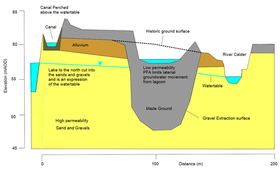
There is the options to import water into the Brookfoot wetland. This could be from the river, canal and/or the water-ski/fishing lakes. The relationship between water tables, ski lake, canal, rivers and the central lagoon is shown in the conceptual model.
The lake to the north and the River Calder to the south tie into the water table. The central lagoon is supported by the made ground of low porous pulverised fly ash. The water in the lagoon is perched above the local water table. There is little lateral groundwater movement out of it. The canal is also perched above the local water table. It offers a sustainable option for gravity feeding water into the Reserve.
The 'preferred option' is to abstract water from the Calder and Hebble Navigation. Works are planned for late 2022/early 2023. We will use grants from the European Investment Structure Fund and partnership support from various groups. The project is also part of the wider Brighouse Flood Alleviation Scheme. It is funded by the European Regional Development Fund.
The Canal
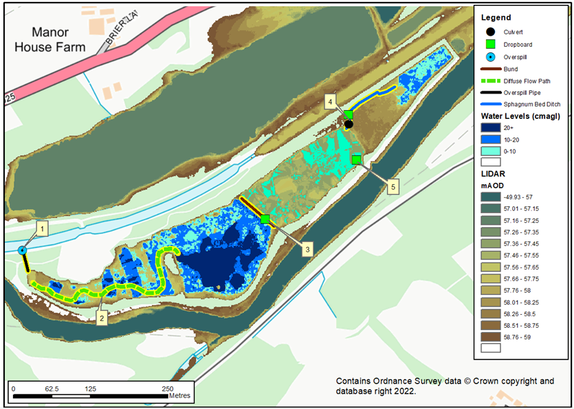
The canal as a water supply is shown on the enhanced LIDAR (ground radar) map. Construction of an additional overspill will pick–up the water that is currently lost to the river. It will redirect it into the top of the wet woodland system. The current and new overspill heights will maintain the canal level and control water flows into the Brookfoot wetlands.
Sphagnum Bog habitat at Cromwell
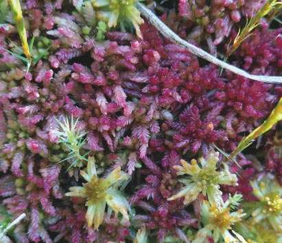
The Brookfoot part of the Cromwell Bottom Nature Reserve supports a rather remarkable area of Sphagnum-rich bog habitat. It has developed over the pulverized fuel ash (PFA) substrate.
Sphagnum moss is a key part of various bog communities and is very good at carbon capture. It has long been recognised as a coloniser of pools and wet areas on former industrial sites. Less so now the acidity of rainwater is decreasing. However, no records of it colonising wet areas on PFA, like at Cromwell Bottom Nature Reserve are easily available.
This vegetation supports a small colony of red Sphagnum medium. A notable species of bog-moss more typically found on deeper peats in undisturbed mire systems. Cromwell Bottom is the only known natural site for this species in South West Yorkshire. The other known site, Thorne Moors, had the species introduced.
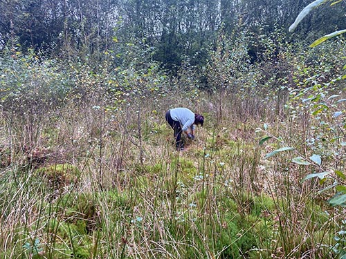
The most apparent threat to the life of the mire is the invasion of scrub. The mire is small for such habitats in the lowland. It is vulnerable to drying, which is made worse by scrub invasion.
Current management involves the removal of the invading scrub. This is carried out by volunteers led by Calderdale Council as part of the general reserve maintenance.
The long-term success of Sphagnum growth seems to depend on the mix of:
- Scrub control.
- Influx of sufficient water.
The latter is by no means guaranteed in a changing climate.